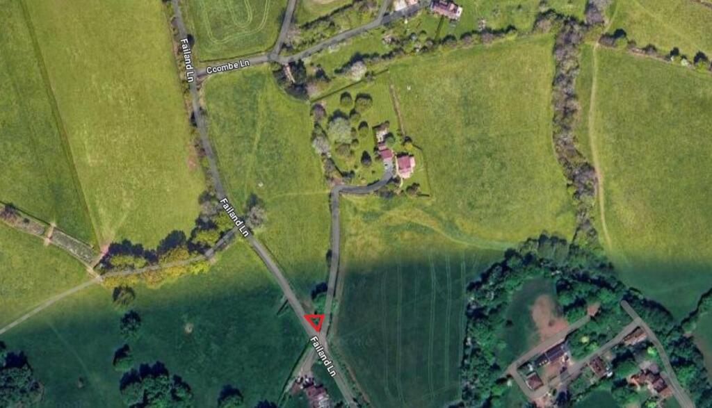
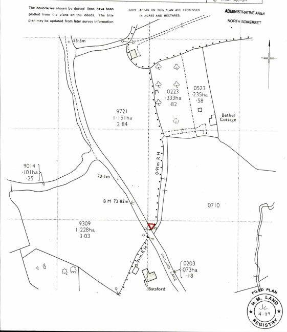
Failand Lane, Failand, Bristol, Somerset, BS8
By West Coast Properties
£ 30,000
Reviews
0 out of 5 stars
West Coast Properties says ..
Small plot of land for sale off failand lane - it is described as Land On The North East Side Of Failand Lane - Guide Price £30,000. A freehold plot of land which could suit a variety of uses.
Property Oracle says ..
The property is located in Failand, a village in North Somerset, with a list price significantly below the average for the area. The lack of information regarding the property’s size, condition, and features makes a comprehensive analysis difficult. However, given the low list price of £30,000 compared to the average house price of £740,833 in the area, it is likely a plot of land or a property requiring substantial renovation. Nearby properties range from £450,000 to over £1,000,000, indicating a substantial difference in value. The surrounding area includes schools, transportation links (though distances aren’t specified), and other amenities, suggesting a reasonably desirable location, though more specifics are needed to assess its quality accurately. The available images show a rural setting with land, suggesting potential for development, but the lack of building details prevents a conclusive assessment of condition.
Therefore, we give this property 1 / 10. *Disclaimer: This is our option and does constitute a recommendation or financial advice. Do your own research. *
- Price
- 1
- Condition
- 0
- Location
- 0
- Land
- 0
- Bedrooms
- 0
- Bathrooms
- 0
The heatmap indicates the level of crime in the area. The color of the heatmap indicates the crime severity and recency.
Metrics Year-on-Year
- Average area value
- 881,250.00 £Increased by 10.74 %
- Average area rental value
- 1,300.00 £/moDecreased by 43.36 %
- Est rental Yield
- 1.77 %Decreased by 48.84 %
- Crime Rate
- 1.00 %Unchanged by 0.00 %
Agent Activity
West Coast Properties created the listing.
Nearby Schools
| Name | Type | Ofsted | Distance |
|---|---|---|---|
| St Mary'S Church Of England Primary School, Portbury | Academy Converter | Good | 1.62 KM |
| Crockerne Children'S Centre | Children's Centre | 2.46 KM | |
| Crockerne Church Of England Primary School | Academy Converter | Good | 2.47 KM |
| The Downs Preparatory School | Other Independent School | 2.59 KM | |
| St Katherine'S School | Academy Converter | Requires improvement | 3.40 KM |
Images
Nearby Streets
| Name | Average Price | Average Sqft | Distance |
|---|---|---|---|
| Coombe Lane | £ 0 | 0 | 0.00 KM |
| Gordano Round | £ 0 | 0 | 0.00 KM |
| Saint Georges Hill | £ 680,970 | 0 | 0.00 KM |
| Saint Georges Close | £ 475,000 | 0 | 0.00 KM |
| Walnut Close | £ 380,000 | 0 | 0.00 KM |
Nearby Transport
| Name | NLC | TLC | Distance |
|---|---|---|---|
| Shirehampton | 3206 | SHH | 3.80 KM |
| Avonmouth | 3200 | AVN | 4.16 KM |
| St Andrews Road | 3252 | SAR | 5.58 KM |
| Sea Mills | 3254 | SML | 6.53 KM |
| Nailsea And Backwell | 3389 | NLS | 6.92 KM |
Nearby Listings
| Address | Price | Type | Score | Distance |
|---|---|---|---|---|
| Failand Lane, Failand, Bristol, Somerset, BS8 | £ 30,000 | BUY | 1 / 10 | 0.00 KM |
| Period detached 5 bedroom house set in 0.35 of an acre in rural Lower Failand | £ 1,100,000 | BUY | Unknown | 0.89 KM |
| Sandy Lane, Lower Failand, Bristol, BS8 | £ 1,150,000 | BUY | 8 / 10 | 0.99 KM |
| St. Georges Hill, Easton-in-Gordano, North Somerset, BS20 | £ 700,000 | BUY | 8 / 10 | 1.29 KM |
| St. Georges Hill, Easton-in-Gordano, North Somerset, BS20 | £ 300,000 | BUY | Unknown | 1.35 KM |
Nearby Properties
| Address | Price | Distance |
|---|---|---|
| Batsford | £ 1,146,000 | 0.06 KM |
| Elm Tree Cottage | £ 1,290,000 | 0.33 KM |
| Hill View Farm | £ 1,285,000 | 0.76 KM |
| Chantry Mews | £ 539,500 | 0.84 KM |
| 30 St Georges Hill | £ 680,000 | 1.28 KM |