
Sherburn in Elmet, Land off Hall Lane, Newthorpe, LS25 6JS
By Bartles Ltd
£ 85,000
Bartles Ltd says ..
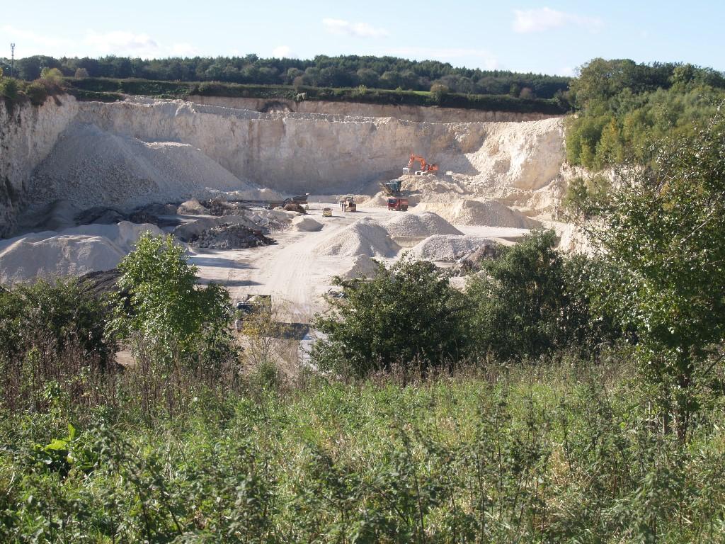
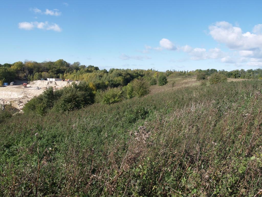
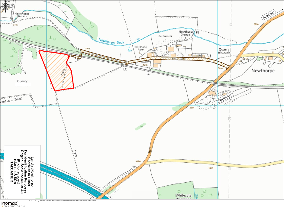
NORTH YORKSHIRE - SELBY DISTRICT <br /> <br />AN ENCLOSURE OF LAND <br />About 7 ? ACRES Total <br /> <br />Situated off HALL LANE, NEWTHORPE (LS25 6JS) <br />BETWEEN SHERBURN & MICKLEFIELD <br /> <br /> <br />FOR SALE BY PRIVATE TREATY <br /> <br />A parcel of restored grass and amenity land with self sown wood to the margin, the whole extending in total to 7.39 acres or thereabouts with access off Hall Lane either directly or by way of an unmade track having crossed by a level gated crossing over the Leeds-Selby rail line. It lies to the west of the village of Sherburn and heading up and through Newthorpe hamlet. <br /> <br />Price Guide £85,000 <br /> <br />Viewing in daylight hours with these particulars <br /> <br />Property ref: BC/333 <br /> <br /> <br />SITUATION: <br />The property is situated in a rural area, 2 miles to the south west of the village of Sherburn, itself about 14 miles east of Leeds, bounded by agricultural land to the east and south while to the west the now re-opened Newthorpe Lime Quarry is currently active. <br /> <br />DESCRIPTION: <br />The land, excepting the wooded areas, is predominantly of longstanding permanent grass suitable for grazing or mowing but significantly, the attributes are considerably aided by the well established regenerated boundary woodland and the out of village location and so of potential interest to those with other interests. The site has historically been restored from a limestone quarry and back filled in 1980's under a local authority run scheme and capped off and restored. It is initially relatively level but with the western side battered down to a significant gradient giving opportunities for further tipping - subject to planning. <br /> <br />SCHEDULE: Recorded on RLR with the RPA. <br /> <br />BPS ENTITLEMENTS: There are none attaching. Qualifying purchaser/s with sufficient other land (total 12 acres required) may acquire entitlements in the open market to be eligible for BPS payments - further detail is available from the Agents. <br /> <br />BOUNDARIES: Where indicated, boundaries marked by an inwards 'T' are understood to be or will be designated the responsibility of the purchaser. Those (if any) shown braced are subject to joint maintenance. <br /> <br />SERVICES: It is understood a water main is located in Hall Lane and a connection would be needed from Yorkshire Water subject to terms and conditions and appropriate easements being negotiated. <br /> <br />DRAINAGE: None recorded. <br /> <br />PLANNING: The land is shown allocated as GB1 (Green Belt) without development limits under policy saved elements of the Selby Local Plan. The designation will restrict development opportunities unless related to agriculture or forestry. <br /> <br />ENVIRONMENT: The site is recorded with the Environment Agency as having been backfilled by Selby Council to the quarry void. The record is available for inspection and confirms the operations ran from 1973 and concluded in 1984. <br /> <br />POSSESSION: Vacant possession is to be granted upon completion. <br /> <br />CROPS: Grass - capable of being mown. <br /> <br />VALUATION: No additional valuation is required. <br /> <br />RIGHTS: <br />Variously, rights of access are reserved from adjoining properties. <br /> <br />RESERVATIONS: None. <br /> <br />OUTGOINGS: Drainage rate - not assessed. No other outgoings are noted. <br /> <br />LOCAL AUTHORITY: Selby District Council, The Civic Centre Doncaster Road, Selby YO8 9FT. Minerals - North Yorkshire County Council, County Hall, Northallerton DL7 8AH. <br /> <br />DIRECTIONS: <br />From Sherburn village centre head west towards Leeds on the B1222 Road and well before the railway underbridge and Squires Café find the junction to Newthorpe on the right, which follow through the hamlet and either use and proceed through the gated level crossing onto the grass track or follow on Hall Lane for 300m to find the underpass to the rail line and on passing through, the field is located pretty much immediately on the left hand side identified by the agent's 'for sale' boards. <br /> <br /> <br /> <br /> <br />We try hard to make our sales details accurate and reliable. If there is any point which is of special importance to you, please contact our office and we will be pleased to check the information. The plans and areas are provided as a guide and no warranty is given as to their correctness.
- Bedrooms
- 0
- Bathrooms
- 0
- Lot (est)
- 2,862.00
The heatmap indicates the level of crime in the area. The color of the heatmap indicates the crime severity and recency.
Metrics Year-on-Year
- Average area value
- 227,143.00 £Decreased by 21.02 %
- Average area rental value
- 1,237.00 £/moIncreased by 11.34 %
- Est rental Yield
- 6.54 %Increased by 40.95 %
- Crime Rate
- 0.00 %
Agent Activity
Bartles Ltd created the listing.
Nearby Schools
| Name | Type | Ofsted | Distance |
|---|---|---|---|
| Sherburn High School | Academy Converter | 2.20 KM | |
| Sherburn In Elmet, Athelstan Community Primary School | Community School | Good | 2.82 KM |
| Sherburn Children'S Centre | Children's Centre | 2.97 KM | |
| Sherburn Hungate Primary School | Academy Converter | 3.17 KM | |
| South Milford Primary School | Academy Converter | 3.21 KM |
Images

Nearby Transport
| Name | NLC | TLC | Distance |
|---|---|---|---|
| South Milford | 8142 | SOM | 3.04 KM |
| Sherburn-In-Elmet | 8257 | SIE | 4.99 KM |
| Micklefield | 8477 | MIK | 5.49 KM |
| Church Fenton | 8233 | CHF | 6.87 KM |
| Knottingley | 8546 | KNO | 9.43 KM |
Nearby Listings
| Address | Price | Type | Score | Distance |
|---|---|---|---|---|
| Sherburn in Elmet, Land off Hall Lane, Newthorpe, LS25 6JS | £ 85,000 | COMMERCIAL_BUY | Unknown | 0.00 KM |
Nearby Properties
| Address | Price | Distance |
|---|---|---|
| Woodland View | £ 247,500 | 0.84 KM |
| Gorse Cottage | £ 496,000 | 0.84 KM |
| 26 Hall Lane | £ 142,500 | 1.58 KM |
| 16 Hall Lane | £ 195,000 | 1.58 KM |
| 18 Hall Lane | £ 230,000 | 1.58 KM |