132 Lichfield Street, Walsall, West Midlands, WS1 1SL
By Harris Lamb
£ 795,000
Reviews
2 out of 5 stars
Harris Lamb says ..
Location: The Site is approximately half a mile from Walsall Train Station and has easy access to the M5/M6/ M54 motorways (J10 M6 1.7 miles) Walsall Town Centre and all facilities - 1.2 miles, and Birmingham City Centre 11 miles. Located on Lichfield Street, it is within the town centre of Wal...
Property Oracle says ..
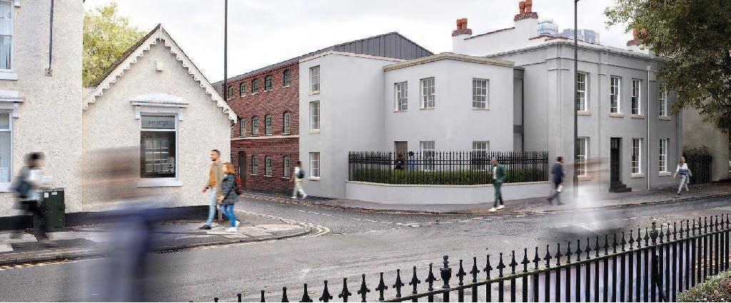
This listing from Harris Lamb presents a development opportunity in Walsall, West Midlands. The property at 132 Lichfield Street is being sold as land only, with no details on plot size or existing structures. The listing highlights the site’s strategic location. Approximately half a mile from Walsall Train Station, it also offers convenient access to major motorways (M5/M6/M54) and Walsall town centre. The surrounding area includes numerous amenities, including highly-rated schools such as Queen Mary’s High School and Walsall College. While the proximity to transport links and amenities is a considerable advantage, the absence of information regarding the plot’s size, development potential, and planning permissions makes a comprehensive evaluation of the list price challenging. The lack of specifics about the land itself poses a risk for potential buyers, and the high list price, therefore, needs careful consideration in relation to any development plans. The images show modern-looking buildings, suggesting a high quality of construction, if these are directly pertinent to the sale. Overall, this property represents a potentially lucrative development venture for experienced investors, provided thorough due diligence is conducted to ascertain the viability of the project given the overall price.
Therefore, we give this property 5 / 10. *Disclaimer: This is our option and does constitute a recommendation or financial advice. Do your own research. *
- Price
- 6
- Condition
- 8
- Location
- 7
- Land
- 1
- Bedrooms
- 0
- Bathrooms
- 0
The heatmap indicates the level of crime in the area. The color of the heatmap indicates the crime severity and recency.
Metrics Year-on-Year
- Average area value
- 308,182.00 £Increased by 29.01 %
- Average area rental value
- 811.00 £/moDecreased by 5.59 %
- Est rental Yield
- 3.16 %Decreased by 26.85 %
- Crime Rate
- 20.00 %Unchanged by 0.00 %
Agent Activity
Harris Lamb created the listing.
Nearby Schools
| Name | Type | Ofsted | Distance |
|---|---|---|---|
| Queen Mary'S High School | Academy Converter | Outstanding | 0.46 KM |
| Walsall College | Further Education | Good | 0.59 KM |
| Butts Primary School | Community School | Good | 0.59 KM |
| Walsall Studio School | Studio Schools | Good | 0.60 KM |
| Blue Coat Church Of England Academy | Academy Sponsor Led | Good | 0.61 KM |
Images
Nearby Streets
| Name | Average Price | Average Sqft | Distance |
|---|---|---|---|
| Whittimere Street | £ 0 | 0 | 0.00 KM |
| Eyland Grove | £ 0 | 0 | 0.00 KM |
| Union Street | £ 175,000 | 0 | 0.00 KM |
| Butler's Precinct | £ 0 | 0 | 0.00 KM |
| Bank Street | £ 0 | 0 | 0.00 KM |
Nearby Transport
| Name | NLC | TLC | Distance |
|---|---|---|---|
| Walsall | 1216 | WSL | 0.77 KM |
| Bescot Stadium | 1003 | BSC | 2.95 KM |
| Tame Bridge Parkway | 1010 | TAB | 3.71 KM |
| Bloxwich | 1141 | BLX | 5.13 KM |
| Bloxwich North | 1018 | BWN | 6.19 KM |
Nearby Listings
| Address | Price | Type | Score | Distance |
|---|---|---|---|---|
| 132 Lichfield Street, Walsall, West Midlands, WS1 1SL | £ 795,000 | BUY | 5 / 10 | 0.00 KM |
| Lower Forster Street, Walsall, WS1 1XB | £ 169,950 | BUY | 6 / 10 | 0.15 KM |
| Bridge Street, Walsall | £ 100,000 | BUY | 5 / 10 | 0.16 KM |
| Bridge Street, Walsall, WS1 | £ 120,000 | BUY | 8 / 10 | 0.18 KM |
| 24 Tameway Plaza 48 Bridge street Walsall WS1 1JZ | £ 95,000 | BUY | 5 / 10 | 0.21 KM |
Nearby Properties
| Address | Price | Distance |
|---|---|---|
| 10 Lower Forster Street | £ 97,000 | 0.17 KM |
| 7 Lower Forster Street | £ 155,000 | 0.18 KM |
| 9 Lower Forster Street | £ 120,000 | 0.18 KM |
| 42 Terret Close | £ 125,000 | 0.23 KM |
| 6 Terret Close | £ 123,500 | 0.23 KM |