A Plot with full planning permission for the erection of a dwelling at Elston Lane, Elston, Grimsargh, Preston, PR2 5LR
By P Wilson & Company
£ 300,000
Reviews
3 out of 5 stars
P Wilson & Company says ..
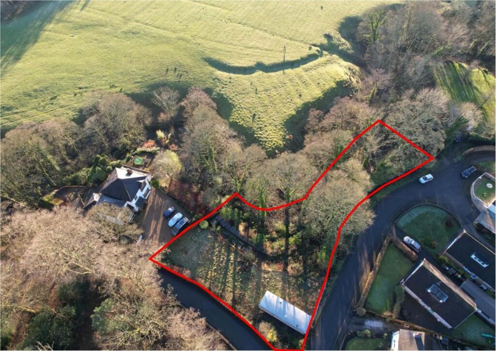
The opportunity to acquire a substantial plot (0.145 hectares or thereabouts) with the benefit of full planning consent for the erection of a detached dwelling at Elston Lane, Elston, Grimsargh, Preston, Lancashire, PR2 5LR.The land includes an area of mature woodland plot bordering Tun Brook.
Property Oracle says ..
This property listing presents a development opportunity: a plot of land with full planning permission for a new dwelling in Grimsargh, Preston. Grimsargh is a sought-after village with good schools, suggesting family-friendly appeal. The plot’s size, shown in the aerial photograph, is significant, offering potential for a substantial property with a degree of privacy given its positioning. Nearby property sales data, while lacking specific sqft details, indicate a range of property values in the area, with some reaching beyond £500,000 for detached houses. The £300,000 listing price is influenced by the fact it is just land with planning permission. Therefore, the listed price will encompass the land cost, the potential construction cost, and the development profit margin. Prospective buyers should undertake thorough due diligence and obtain accurate construction cost estimates before committing to a purchase. The absence of precise plot measurements and property specifications requires caution in interpreting the price and value. Buyers should carefully weigh the investment risks and potential rewards before committing to this project.
Therefore, we give this property 6 / 10. *Disclaimer: This is our option and does constitute a recommendation or financial advice. Do your own research. *
- Price
- 7
- Condition
- 4
- Location
- 7
- Land
- 6
- Bedrooms
- 0
- Bathrooms
- 0
The heatmap indicates the level of crime in the area. The color of the heatmap indicates the crime severity and recency.
Metrics Year-on-Year
- Average area value
- 322,630.00 £Decreased by 7.75 %
- Average area rental value
- 1,067.00 £/moDecreased by 13.67 %
- Est rental Yield
- 3.97 %Decreased by 6.37 %
- Crime Rate
- 110.00 %Unchanged by 0.00 %
Agent Activity
P Wilson & Company created the listing.
Nearby Schools
| Name | Type | Ofsted | Distance |
|---|---|---|---|
| Alston Lane Catholic Primary School, Longridge | Voluntary Aided School | Good | 1.08 KM |
| Grimsargh St Michael'S Church Of England Primary School | Voluntary Aided School | Outstanding | 1.73 KM |
| Longridge High School | Community School | Requires improvement | 2.86 KM |
| St Cecilia'S Rc High School | Voluntary Aided School | Good | 2.88 KM |
| Longridge St Wilfrid'S Roman Catholic Primary School | Voluntary Aided School | Good | 3.44 KM |
Images
Nearby Streets
| Name | Average Price | Average Sqft | Distance |
|---|---|---|---|
| Maple Grove | £ 279,950 | 0 | 0.00 KM |
| Cradle Court | £ 395,000 | 0 | 0.00 KM |
| Oban Court | £ 430,000 | 0 | 0.00 KM |
| Cotton Street | £ 0 | 0 | 0.00 KM |
| Bullfinch Grove | £ 0 | 0 | 0.00 KM |
Nearby Transport
| Name | NLC | TLC | Distance |
|---|---|---|---|
| Bamber Bridge | 2561 | BMB | 9.66 KM |
Nearby Listings
| Address | Price | Type | Score | Distance |
|---|---|---|---|---|
| A Plot with full planning permission for the erection of a dwelling at Elston Lane, Elston, Grimsargh, Preston, PR2 5LR | £ 300,000 | BUY | 6 / 10 | 0.00 KM |
| Elston Green, Grimsargh, Lancashire, PR2 | £ 375,000 | BUY | 6 / 10 | 0.06 KM |
| Tunbrook Avenue, Grimsargh, Preston | £ 259,950 | BUY | 7 / 10 | 0.06 KM |
| Elston Lane, Grimsargh, Preston | £ 239,950 | BUY | 6 / 10 | 0.11 KM |
| Tunbrook Avenue, Grimsargh, Preston | £ 229,950 | BUY | 6 / 10 | 0.14 KM |
Nearby Properties
| Address | Price | Distance |
|---|---|---|
| 8 Elston Green | £ 246,000 | 0.01 KM |
| 2 Elston Green | £ 275,000 | 0.03 KM |
| Mill Dam Cottage | £ 350,000 | 0.07 KM |
| 17 Tunbrook Avenue | £ 205,000 | 0.07 KM |
| 19 Tunbrook Avenue | £ 164,000 | 0.07 KM |