
P&
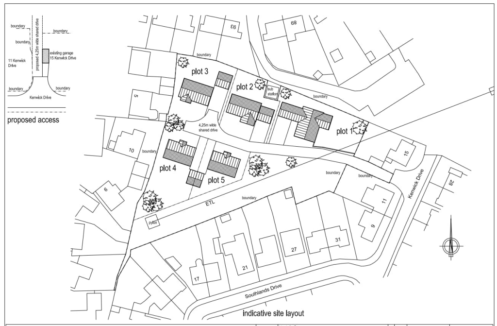
Development Land Kenwick Drive, Grantham, NG31 9DP
By P&F
£ 235,000
P&F says ..
Land with Outline Consent for 5 Dwellings - FOR SALE Immediate ‘exchange of contracts’ available Sold via ‘Secure Sale’ Auction
- Bedrooms
- 0
- Bathrooms
- 0
The heatmap indicates the level of crime in the area. The color of the heatmap indicates the crime severity and recency.
Metrics Year-on-Year
- Average area value
- 161,250.00 £Decreased by 15.31 %
- Average area rental value
- 716.00 £/moIncreased by 3.17 %
- Est rental Yield
- 5.33 %Increased by 21.97 %
- Crime Rate
- 7.00 %Unchanged by 0.00 %
from 190,411.00 £
from 694.00 £/mo
from 4.37 %
from 7.00 %
Agent Activity
P&F created the listing.
Nearby Schools
| Name | Type | Ofsted | Distance |
|---|---|---|---|
| Springwell Alternative Academy Grantham | Free Schools Alternative Provision | 0.41 KM | |
| The Saint Mary'S Catholic Voluntary Academy | Academy Converter | 0.51 KM | |
| The Harrowby Church Of England Infant School, Grantham | Academy Converter | Good | 0.54 KM |
| The Grantham Sandon School | Academy Special Converter | Outstanding | 0.58 KM |
| St Anne'S Church Of England Primary School, Grantham | Voluntary Controlled School | Good | 0.93 KM |
Images


Nearby Streets
| Name | Average Price | Average Sqft | Distance |
|---|---|---|---|
| Hall Drive | £ 220,000 | 0 | 0.00 KM |
| Ermine Close | £ 0 | 0 | 0.00 KM |
| Garden Close | £ 385,556 | 0 | 0.00 KM |
| Gorse Rise | £ 0 | 0 | 0.00 KM |
| Kipling Close | £ 180,000 | 0 | 0.00 KM |
Nearby Transport
| Name | NLC | TLC | Distance |
|---|---|---|---|
| Grantham | 6469 | GRA | 2.00 KM |
Nearby Listings
| Address | Price | Type | Score | Distance |
|---|---|---|---|---|
| Development Land Kenwick Drive, Grantham, NG31 9DP | £ 235,000 | COMMERCIAL_BUY | Unknown | 0.00 KM |
Nearby Properties
| Address | Price | Distance |
|---|---|---|
| 83 Brittain Drive | £ 88,000 | 0.05 KM |
| 103 Brittain Drive | £ 100,000 | 0.05 KM |
| 97 Brittain Drive | £ 170,000 | 0.05 KM |
| 85 Brittain Drive | £ 40,000 | 0.05 KM |
| 89 Brittain Drive | £ 85,000 | 0.05 KM |