Land Off Park Lane, Lower Brynamman, SA18 1TE
By Calow Evans
£ 59,999
Reviews
2 out of 5 stars
Calow Evans says ..
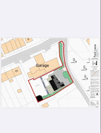
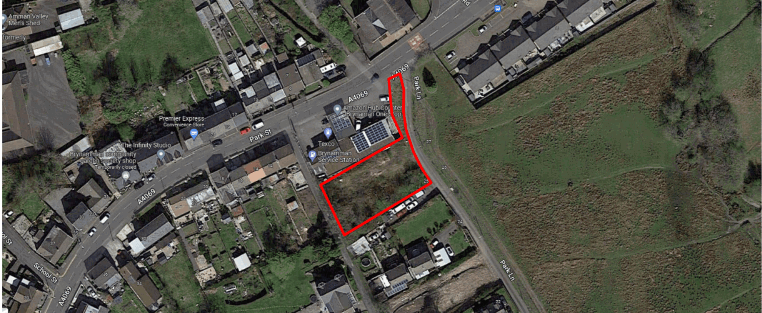
A potential building plot (stpp) situated on a quiet side road in the semi rural village of Lower Brynamman. The land is situated in an elevated position and enjoys countryside views with an open aspect to the side. We are advised by the Vendor that mains services are connected sub...
Property Oracle says ..
This listing presents a potential building plot in Lower Brynamman, a semi-rural village in West Glamorgan. The plot is situated on Park Lane and enjoys countryside views. While the lack of specific plot size and square footage details limits a complete assessment, the aerial imagery depicts a sizable area, possibly suitable for a new build house, subject to planning permission. The proximity to local schools, such as Brynaman CP School (approximately 1.81 km away), might appeal to families. However, the absence of information about nearby transportation and limited details regarding the necessary services connections is a consideration. Nearby property prices vary greatly, with some houses selling well above £100,000, while other building plots have sold significantly cheaper. This indicates a variability in the value of properties and building plots in this area. The list price of £59,999 for this plot is within the range of other plots in the area, but its ultimate value hinges on obtaining necessary planning permission and determining the precise plot size and suitability for a new build. Potential buyers should undertake thorough due diligence and investigate planning regulations and access to utility services before making any investment decision. The absence of any buildings on the plot gives no indication of its condition
Therefore, we give this property 4 / 10. *Disclaimer: This is our option and does constitute a recommendation or financial advice. Do your own research. *
- Price
- 7
- Condition
- 1
- Location
- 4
- Land
- 5
- Bedrooms
- 0
- Bathrooms
- 0
The heatmap indicates the level of crime in the area. The color of the heatmap indicates the crime severity and recency.
Metrics Year-on-Year
- Average area value
- 406,364.00 £Increased by 51.98 %
- Average area rental value
- 1,294.00 £/moIncreased by 17.32 %
- Est rental Yield
- 3.82 %Decreased by 22.83 %
- Crime Rate
- 3.00 %Unchanged by 0.00 %
Agent Activity
Calow Evans created the listing.
Nearby Schools
| Name | Type | Ofsted | Distance |
|---|---|---|---|
| Ygg Gwaun-Cae-Gurwen | Welsh Establishment | 1.35 KM | |
| Tairgwaith Primary School | Welsh Establishment | 1.80 KM | |
| Brynaman C P School | Welsh Establishment | 1.81 KM | |
| Ysgol Y Bedol | Welsh Establishment | 5.61 KM | |
| Yggd Cwmllynfell | Welsh Establishment | 5.63 KM |
Images
Nearby Streets
| Name | Average Price | Average Sqft | Distance |
|---|---|---|---|
| Amman Valley Cycleway | £ 400,000 | 0 | 0.00 KM |
| Stryd Cannon | £ 220,000 | 0 | 0.00 KM |
| Heol Brynamman | £ 175,000 | 0 | 0.00 KM |
| Lon Brynneuadd | £ 180,000 | 0 | 0.00 KM |
| Coronation Road | £ 187,475 | 0 | 0.00 KM |
Nearby Listings
| Address | Price | Type | Score | Distance |
|---|---|---|---|---|
| Land Off Park Lane, Lower Brynamman, SA18 1TE | £ 59,999 | BUY | 4 / 10 | 0.00 KM |
| Park Street, Lower Brynamman, Ammanford, SA18 | £ 87,000 | BUY | 6 / 10 | 0.15 KM |
| 50 Park Street, Lower Brynamman, Ammanford, Carmarthenshire SA18 1TG | £ 45,000 | BUY | 5 / 10 | 0.20 KM |
| Park Street, Lower Brynamman, Ammanford, Carmarthenshire. | £ 45,000 | BUY | 5 / 10 | 0.26 KM |
| Banwen Place, Lower Brynamman, Ammanford | £ 180,000 | BUY | 5 / 10 | 0.28 KM |
Nearby Properties
| Address | Price | Distance |
|---|---|---|
| 19 Park Lane | £ 167,000 | 0.01 KM |
| 6 Park Lane | £ 14,000 | 0.01 KM |
| 13 Park Lane | £ 80,000 | 0.01 KM |
| 2 Park Lane | £ 130,000 | 0.01 KM |
| 11 Park Lane | £ 118,000 | 0.01 KM |