
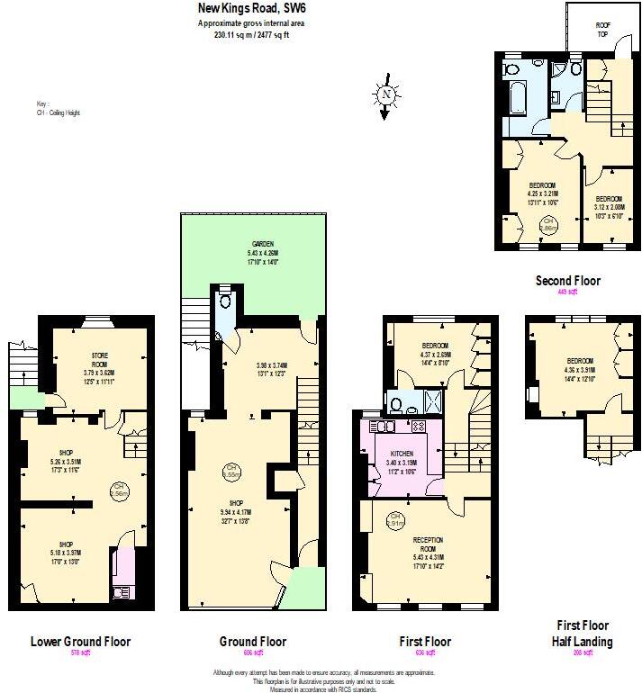
New Kings Road, London
By Brik
£ 1,500,000
Brik says ..
Freehold building - Residential and Commercial use / Occupied until Sept 2026. Development potential.
- Bedrooms
- 0
- Bathrooms
- 0
The heatmap indicates the level of crime in the area. The color of the heatmap indicates the crime severity and recency.
Metrics Year-on-Year
- Average area value
- 1,678,125.00 £Decreased by 1.66 %
- Average area rental value
- 3,992.00 £/moIncreased by 19.56 %
- Est rental Yield
- 2.85 %Increased by 21.28 %
- Crime Rate
- 6.00 %Unchanged by 0.00 %
from 1,706,379.00 £
from 3,339.00 £/mo
from 2.35 %
from 6.00 %
Agent Activity
Brik created the listing.
Nearby Schools
| Name | Type | Ofsted | Distance |
|---|---|---|---|
| Psla Children'S Centre Services At New Kings Family Space | Children's Centre Linked Site | 0.14 KM | |
| Parayhouse School | Non-maintained Special School | Good | 0.26 KM |
| Thomas'S Academy | Academy Converter | Good | 0.26 KM |
| Sulivan Primary School | Academy Converter | Good | 0.43 KM |
| Lady Margaret School | Academy Converter | 0.45 KM |
Images
Nearby Streets
| Name | Average Price | Average Sqft | Distance |
|---|---|---|---|
| Laurel Bank Gardens | £ 570,000 | 0 | 0.00 KM |
| Linver Road | £ 1,150,000 | 0 | 0.00 KM |
| Beaconsfield Alleyway | £ 2,250,000 | 0 | 0.00 KM |
| Swan Mews | £ 0 | 0 | 0.00 KM |
| Novello Street | £ 0 | 0 | 0.00 KM |
Nearby Transport
| Name | NLC | TLC | Distance |
|---|---|---|---|
| West Brompton | 8875 | WBP | 1.86 KM |
| Putney | 5603 | PUT | 1.91 KM |
| Wandsworth Town | 5576 | WNT | 2.06 KM |
| Imperial Wharf | 9586 | IMW | 2.26 KM |
| Kensington (Olympia) | 3092 | KPA | 2.98 KM |
Nearby Listings
| Address | Price | Type | Score | Distance |
|---|---|---|---|---|
| New Kings Road, London | £ 1,500,000 | BUY | Unknown | 0.00 KM |
| Cortayne Road, Parsons Green, SW6 | £ 1,100,000 | BUY | Unknown | 0.02 KM |
| Cortayne Road, Parsons Green | £ 1,100,000 | BUY | 6 / 10 | 0.03 KM |
| New Kings Road, Parsons Green, SW6 | £ 900,000 | BUY | Unknown | 0.03 KM |
| New King's Road, Parsons Green, London, SW6 | £ 550,000 | BUY | 6 / 10 | 0.03 KM |
Nearby Properties
| Address | Price | Distance |
|---|---|---|
| 289b New Kings Road | £ 315,000 | 0.02 KM |
| 299a New Kings Road | £ 335,000 | 0.02 KM |
| 18 Cortayne Road | £ 1,450,000 | 0.06 KM |
| 5 Cortayne Road | £ 1,670,000 | 0.06 KM |
| 4 Cortayne Road | £ 935,000 | 0.06 KM |