Andrew Craig says ..
Welcome to this Extended Four Bedroom Semi-Detached House, ideally located in this highly desirable area. Perfect for growing families or those seeking generous living space, this charming home offers comfort, versatility, and convenience all in one. Whitburn village amenities are nearby, along...
Property Oracle says ..
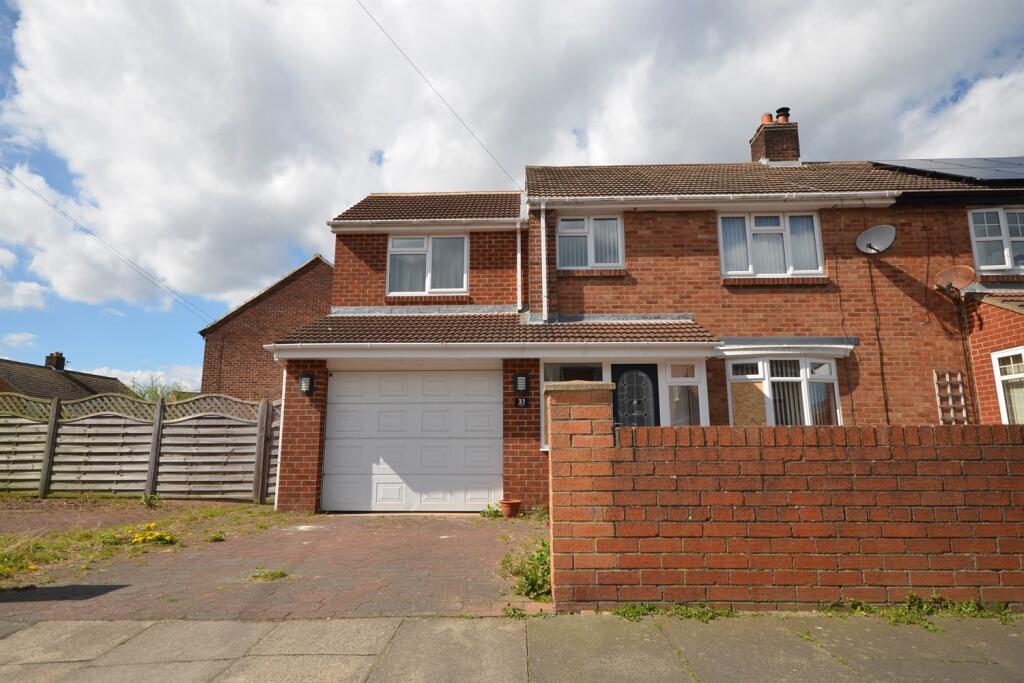
This property is a semi-detached house located on Parry Drive in Whitburn, South Tyneside. The area benefits from relatively close proximity to several schools, including Whitburn Church of England Academy (Good Ofsted rating) and Whitburn Village Primary School (Good Ofsted rating), both within a kilometre. Sunderland train station is also within reasonable travelling distance at 5.49km. The property itself appears to be in reasonable condition from the image provided. While there is no visible major damage, the overall presentation suggests a need for some external maintenance, such as tidying the front garden. The brickwork looks sound, and the windows and roof appear intact. The listing price of £220,000 is slightly below the average price for the area (£292,923), however, without the square footage of the property, a precise comparison to the average price per square foot (£396) cannot be made. Nearby comparable properties on Parry Drive range from £110,000 to £160,000, suggesting that the list price may be at the higher end of the market value for this street. Further information on the property’s internal condition and size would be needed to provide a more conclusive assessment of the price’s reasonableness. The lack of plot size information prevents a comment on the amount of land available with the property.
Therefore, we give this property 6 / 10. *Disclaimer: This is our option and does constitute a recommendation or financial advice. Do your own research. *
- Price
- 6
- Condition
- 7
- Location
- 7
- Land
- 0
- Bedrooms
- 4
- Bathrooms
- 2
The heatmap indicates the level of crime in the area. The color of the heatmap indicates the crime severity and recency.
Metrics Year-on-Year
- Average area value
- 336,607.00 £Increased by 20.98 %
- Average area rental value
- 852.00 £/moDecreased by 14.63 %
- Est rental Yield
- 3.04 %Decreased by 29.30 %
- Crime Rate
- 16.00 %Unchanged by 0.00 %
Agent Activity
Andrew Craig created the listing.
Nearby Schools
| Name | Type | Ofsted | Distance |
|---|---|---|---|
| Whitburn Church Of England Academy | Academy Converter | Good | 0.56 KM |
| Whitburn And Marsden Children'S Centre | Children's Centre | 0.57 KM | |
| Whitburn Village Primary School | Community School | Good | 0.57 KM |
| Marsden Primary School | Community School | Good | 0.98 KM |
| Fulwell Junior School | Community School | Outstanding | 2.52 KM |
Images
Nearby Streets
| Name | Average Price | Average Sqft | Distance |
|---|---|---|---|
| Birch Avenue | £ 0 | 0 | 0.00 KM |
| Hillside Drive | £ 221,667 | 0 | 0.00 KM |
| Buckingham Close | £ 0 | 0 | 0.00 KM |
| Central Avenue | £ 189,000 | 0 | 0.00 KM |
| Moor View | £ 162,625 | 0 | 0.00 KM |
Nearby Transport
| Name | NLC | TLC | Distance |
|---|---|---|---|
| Sunderland | 7640 | SUN | 5.49 KM |
Nearby Listings
| Address | Price | Type | Score | Distance |
|---|---|---|---|---|
| Parry Drive, Whitburn | £ 220,000 | BUY | 6 / 10 | 0.00 KM |
| Parry Drive, Whitburn | £ 170,000 | BUY | 6 / 10 | 0.00 KM |
| Farrow Drive, Whitburn, Sunderland, Tyne and Wear, SR6 7BQ | £ 205,000 | BUY | 7 / 10 | 0.13 KM |
| Highcroft Drive, Whitburn | £ 179,950 | BUY | 7 / 10 | 0.15 KM |
| Birch Avenue, Sunderland | £ 130,000 | BUY | 6 / 10 | 0.21 KM |
Nearby Properties
| Address | Price | Distance |
|---|---|---|
| 2 Parry Drive | £ 116,000 | 0.05 KM |
| 24 Parry Drive | £ 110,000 | 0.05 KM |
| 8 Parry Drive | £ 124,950 | 0.05 KM |
| 17 Parry Drive | £ 203,000 | 0.05 KM |
| 5 Parry Drive | £ 139,000 | 0.05 KM |