
Land on the South East Side of Burns Street, Heanor, Derbyshire
By Henrys Simms
£ 500,000
Reviews
2 out of 5 stars
Henrys Simms says ..
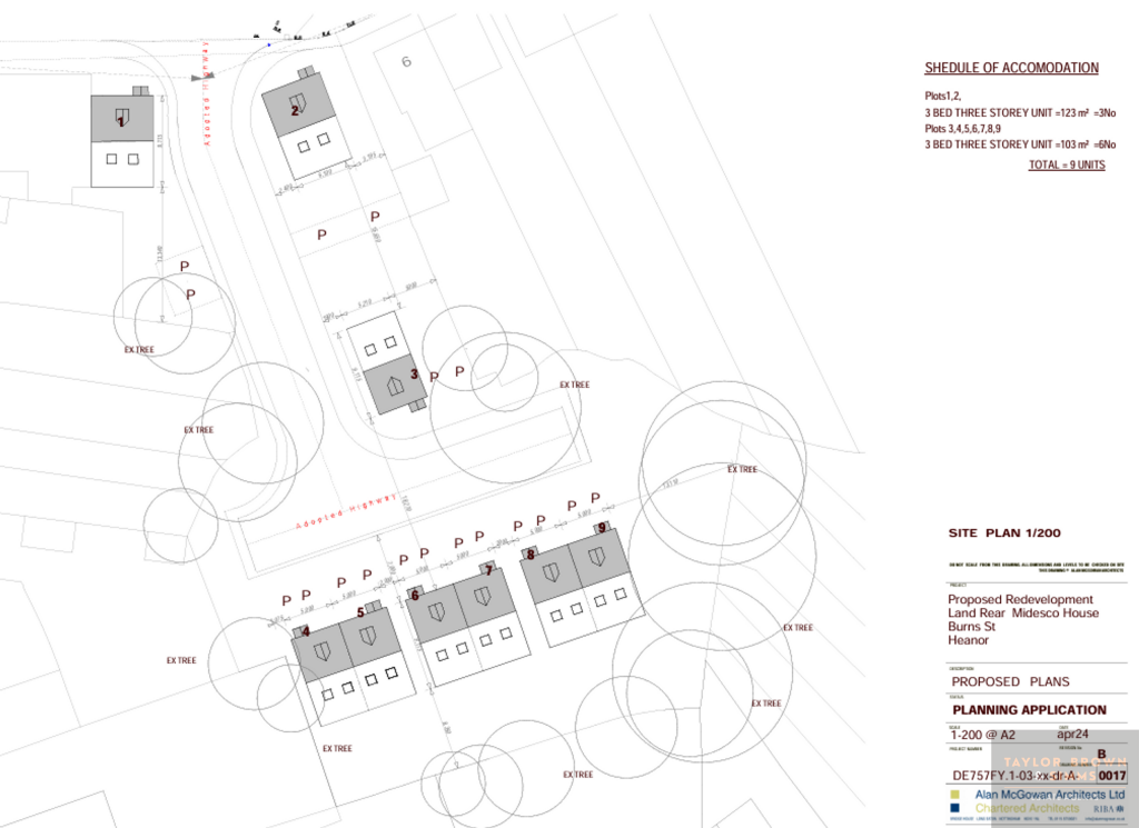
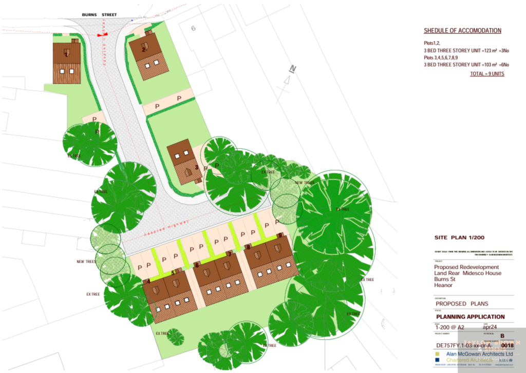
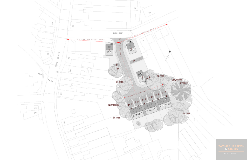
****DEVELOPMENT OPPORTUNITY**** Close to Heanor Town Centre. Proposed residential development of nine houses, with access road and parking. Amber Valley Council Reference : PLANNING PERMISSION GRANTED - AVA/2024/0485 for nine three bedroom dwellings.
Property Oracle says ..
The property is land located in Heanor, Derbyshire. The listing price is £500,000. The average property price in the area is £221,234, and the average price per square foot is £236. The listing price of this land seems high compared to the average property price in the area. However, this is land for development. The land is located on Burns Street, where nearby properties have sold for between £83,950 and £111,000. There are several schools located within 1.5km of the property, including Howitt Primary Community School, Corfield Cofe Infant School, Jasmine House School, Heanor Gate Spencer Academy, and Mundy Cofe Junior School. The nearest train station is Langley Mill, which is 3.30km away. Based on the images, the land appears to be suitable for building 9 units.
Therefore, we give this property 5 / 10. *Disclaimer: This is our option and does constitute a recommendation or financial advice. Do your own research. *
- Price
- 3
- Condition
- 0
- Location
- 6
- Land
- 7
- Bedrooms
- 3
- Bathrooms
- 0
The heatmap indicates the level of crime in the area. The color of the heatmap indicates the crime severity and recency.
Metrics Year-on-Year
- Average area value
- 178,750.00 £Decreased by 27.19 %
- Average area rental value
- 583.00 £/moDecreased by 41.05 %
- Est rental Yield
- 3.91 %Decreased by 19.05 %
- Crime Rate
- 17.00 %Unchanged by 0.00 %
Agent Activity
Henrys Simms created the listing.
Nearby Schools
| Name | Type | Ofsted | Distance |
|---|---|---|---|
| Howitt Primary Community School | Academy Converter | 0.36 KM | |
| Corfield Cofe Infant School | Voluntary Controlled School | Good | 0.73 KM |
| Jasmine House School | Other Independent Special School | Outstanding | 1.23 KM |
| Heanor Gate Spencer Academy | Academy Converter | Good | 1.34 KM |
| Mundy Cofe Junior School | Voluntary Controlled School | Good | 1.38 KM |
Images
Nearby Streets
| Name | Average Price | Average Sqft | Distance |
|---|---|---|---|
| John Street | £ 192,498 | 0 | 0.00 KM |
| A608 | £ 0 | 0 | 0.00 KM |
| Derby Road | £ 0 | 0 | 0.00 KM |
| Spring Lane | £ 0 | 0 | 0.00 KM |
| Red Lion Square | £ 0 | 0 | 0.00 KM |
Nearby Transport
| Name | NLC | TLC | Distance |
|---|---|---|---|
| Langley Mill | 1761 | LGM | 3.30 KM |
| Ilkeston | 7783 | ILN | 8.47 KM |
| Alfreton | 1805 | ALF | 9.22 KM |
Nearby Listings
| Address | Price | Type | Score | Distance |
|---|---|---|---|---|
| Land on the South East Side of Burns Street, Heanor, Derbyshire | £ 500,000 | BUY | 5 / 10 | 0.00 KM |
| Cherry Blossom House , Burns Street | £ 249,950 | BUY | 6 / 10 | 0.08 KM |
| Loscoe Road, Heanor, Derbyshire | £ 155,000 | BUY | 6 / 10 | 0.09 KM |
| Cherry Blossom House, Burns Street, Heanor | £ 244,950 | BUY | 7 / 10 | 0.09 KM |
| Burns Street, Heanor, DE75 | £ 130,000 | BUY | 6 / 10 | 0.09 KM |
Nearby Properties
| Address | Price | Distance |
|---|---|---|
| 26 Burns Street | £ 111,000 | 0.08 KM |
| 30 Burns Street | £ 84,000 | 0.08 KM |
| 24 Burns Street | £ 83,950 | 0.08 KM |
| 1 Burns Street | £ 19,000 | 0.08 KM |
| 8 Burns Street | £ 106,500 | 0.08 KM |